date_range
Saturday 24 Jan 2026


 LOCAL EDITION
close
LOCAL EDITION


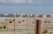
Sand drifting from Gulhifalhu are pictured reaching the neighboring island of Vilimale'. (Photo/Save the Beach)
Divers and resorts have been enunciating the destructive impact of the reclamation project for the planned commercial port in Gulhifalhu. The massive land reclamation phase has already begun, leaving divers and resorts alarmed at the damage it could cause to the ecosystem.
The EIA report of the project had included concerns expressed by stakeholders regarding the project. These concerns have come from resorts, dive associations, fishermen as well as environmental organizations.
The project could result in the destruction of coral reefs and marine life, which would, in turn, affect the tourism industry. Fishermen have also expressed refusal towards the project.
The Planning Ministry has stated that steps will be undertaken to ensure the sediments deposited to the location would be prevented from drifting into the sea. The Ministry stated so after conducting an Environmental Impact Assessment of the first phase for the project which is, land reclamation.
Gulhifalhu was first reclaimed in 2010. The initial ten hectares were increased to 30 in a reclamation project conducted in 2013. The current project will see a whopping 192 hectares reclaimed in just a year.
Planning Ministry already has plans to develop the commercial harbor in the location during the second phase of the project.
Sand for the project is to be mined from the 13 km stretch of sea between Male’ and Gulhifalhu. The company in charge of the sand mining project is the Boskalis Company who will be operating with a suction hopper dredger. Another cause of alarm among stakeholders.
During meetings with stakeholders for the project’s EIA, the Diver’s Association reminded the fact that during the reclamation project for the phase two of Hulhumale’, sand deposited to the area had reached as far as the islands of Bandos.
The area was left murky for months and the surrounding reefs bore the wrath of the reclamation project.
The association has voiced opposition towards such reclamation projects but lamented the fact that they are often ignored.
Revetment projects usually take a long time, the association noted, which in turn meant that sand deposited in the area is left to flow freely with the current. The drifting sand then reaches reefs, which in turn, causes damage to these reefs.

Due to the Gulhifalhu project, the association stated that at least 30 dive sites could be left in harm’s way. Since the area is in close proximity with resorts, this left the door open for the house reefs of these resorts being exposed to danger. It would in turn negatively impact the tourism industry.
Some of the reefs in the path of danger include the Vilimale’ reef and the Manta Point on the South-East of Paradise Island Resort. Protected areas such as the Hans Hass Place, Kuda Huraa, Banana Reef as well as Maagiri will be affected due to this project.
Other than the Diver’s Association, Maldives Association for Tourism Industry (MATI), and resorts in Male’ Atoll also stated their concerns regarding the project.
The resorts spoke from experience when they stated negative impacts were inflicted on their businesses due to reclamation works. Moreover, signs of soil erosion from the beaches of these resorts have also been identified due to such projects.

The area where sand is to be mined for the project is also used by fishing boats to anchor and fish for bait. The biggest concern expressed by the Fishermen’s Association is that the project would cause a reduction of bait in the area. The project would also leave fishing boats unable to anchor in the area.
Complaints against the same company regarding the lack of baitfish were received during a similar project in Kulhudhuffushi.
Responding to these concerns, the Planning Ministry said that the reclamation project would not be conducted in a manner that would see sand drift into the sea.
“Sand Bunds” would be placed around the area as sand is deposited. At first, sand is to be deposited in the deeper sections of the lagoon. This means that once the deeper section is filled, sand is not expected to drift away from the lagoon and the amount of sediment that could create a murkiness in the water would also be limited, said the Ministry.
The Ministry also added that silt screens would not be used throughout the project. But rather, these screens would be used only in areas where sand may drift due to the current. A silt screen or barrier is one of the most effective forms of sediment containment on a construction or reclamation site.
Despite all of these assurances, photos have already begun to emerge from the impact of the project.

Sand deposited on the Gulhifalhu lagoon is already reaching the neighboring island of Vilimale’ by drifting. The water between the two islands are now murky.
The Environmental Protection Agency (EPA) today announced that it will be closely monitoring the Gulhifalhu land reclamation project in order to assess whether the appropriate measures are undertaken to reduce any damage to the environment.
Today, the EPA stated that it would be closely monitoring whether these steps are undertaken. The agency has the power to stop the project if it poses the danger of causing irreversible damage to the environment.